
Solving the Geocoordinates Problem: How FuSE built Groundtruth to Make Capturing Lat/Longs Easy
Accurate charger coordinates are one of the most common reasons clean fuel registrations stall. Here's why programs require them, where they go wrong, and how FuSE built Groundtruth to capture serial number and location in a single photo.

Ask anyone who has registered EV chargers in a clean fuel program what slows them down, and you’ll hear the same answer surprisingly often: latitude and longitude.
Serial numbers, makes and models, port types and nameplate ratings are usually easy to pull together. Accurate coordinates for every single charger are not. Without them, a charger can’t be submitted, and a charger that’s submitted with the wrong ones gets rejected.
So our team built something to fix it. This is the story of why we built Groundtruth, how it works, and what we learned taking it into the field.
Why programs require coordinates
All active North American clean fuel programs (CA LCFS, OR CFP, WA CFS, NM CTFP, Canada CFR, and BC LCFS) ask for charger-level coordinates. The details vary by program, but the core requirement is the same.
One of the biggest reasons is preventing duplicate registrations. A serial number alone should, in theory, rule out duplicates. In practice, the California Air Resources Board (CARB) pairs the serial number with the charger’s latitude and longitude to make sure each physical unit is only registered once.
The bar for precision is high. CARB expects coordinates to be unique and precise for every unit, rounded to at least five decimal places, or roughly one meter. That’s close enough to tell two chargers apart in the same row of parking spaces, and close enough that a pin dropped on the wrong side of a curb will be noticed.
As charger installations multiply and expand at the same sites, agencies are reviewing these submissions more closely than they used to. It hasn’t been fully clarified whether coordinates will fall within the scope of third-party verification, but we’d rather err on the side of accuracy now than find out later.
Where things go wrong
The data usually isn’t in the charger management system (CMS). When we connect to a client’s CMS by API, only about a third include coordinates at all, and fewer still are accurate. Some well-established network operators can be notable exceptions, but even their coordinates aren’t always right.
So people turn to online maps. Most site hosts and operators have never had to collect charger coordinates before, and they come to us looking for a method. The default is Google Maps: right-click on the satellite view and copy the coordinates. That can work when the imagery is recent. But many chargers are installed after the last satellite update, so there’s nothing on the map to confirm them against. And a map pin can’t tell you which serial number belongs to which charger.
Then the pins drift. A common shortcut is to drop a pin at the site address and estimate the rest, assuming chargers run east to west or north to south and dragging pins along. Zoomed out, it looks right. Zoomed in, some pins land inside a building or across the street at a different property. CARB reviews these submissions closely, and we’ve had plenty sent back for exactly this reason.
And every rejection costs time. A rejected charger goes back to the client, or into our own mapping tools, gets corrected, and gets resubmitted. That cycle can stretch across several months before a single charger is approved. Meanwhile, coordinates are often the one missing piece holding up an otherwise complete registration. We’ve come right up against submission deadlines, and with large data sets, clients sometimes miss them. These businesses have plenty of other priorities, and chasing coordinates for chargers already in the ground rarely tops the list.
What we built: Groundtruth
Rather than keep fixing coordinates after the fact, we decided to solve the problem at the source. Using AI as a fast, iterative build tool, our team created Groundtruth, a mobile-friendly web app that captures a charger’s serial number and location in a single photo.
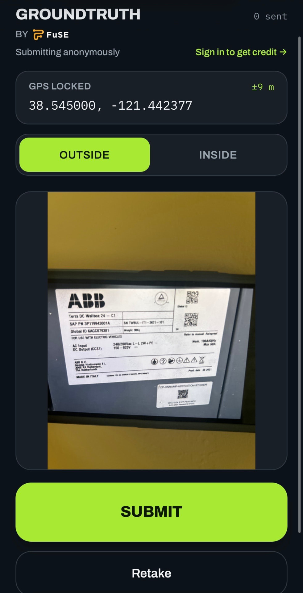
Here’s how it works:
- Open the Groundtruth link on your phone and allow location services (a temporary approval).
- Select “Outside” or “Inside” so the charger’s setting is recorded.
- Stand at the charger and take a photo of the nameplate showing the serial number.
- Optical character recognition (OCR) reads the manufacturer, model (if available) and serial number from the photo, so nothing has to be typed by hand.
- The app records your phone’s coordinates at the moment of capture and pairs them with that serial number.
- Move to the next charger and repeat.
Every submission flows into a clean, formatted database that FuSE can pull from to register or track chargers. Submissions are anonymous and don’t require a login, so anyone with the link can use it from their smartphone. This solves the serial-number-to-location matching problem that map-based methods can’t, because the photo and the coordinates are captured together, by someone standing right at the charger.
Putting it to the test
We spent about a month testing Groundtruth as a team, and we made a game of it with an internal leaderboard. Team members logged chargers around town, near home and on road trips to capture as many charger types as possible. Altogether, we’ve logged a few hundred chargers across several states and countries.
The feedback was consistent. The app is simple, with no complicated features to learn. The slowest part of any site visit is walking from one charger to the next, and a dozen chargers can be logged in just a few minutes. Submissions reach the back end almost instantly, so whoever is receiving notifications sees new entries right away.
Where it gets harder: parking garages. Concrete structures make it difficult for phone location services to pinpoint where you are. Chargers on an exterior wall or open top deck are usually fine. A charger in the middle of the third floor of an eight-story garage is a different story, and an underground garage may get no usable reading at all. Results can vary between Android and iOS devices, since each relies on different networks of mapped Wi-Fi and Bluetooth signals to estimate location, but neither works reliably deep inside concrete.
The workarounds available today are limited. The most practical one is to stand outside the structure, get a good location reading, and drop a single pin on the building, which means every charger inside shares the same coordinates. Estimating each charger’s position more precisely takes GIS software and, ideally, a digital blueprint of the structure, which most owners and operators don’t have on hand. Indoor positioning systems, common in warehouses and some malls, could eventually solve this, but they have to be installed by the building owner and are rare in parking garages today. When chargers are stacked on floors two, three and four, their coordinates can be effectively identical no matter what method is used.
We built Groundtruth to require users to flag indoor versus outdoor locations, so settings are documented firsthand rather than filled in later by guesswork. But the reality is that even the best technology reasonably available to station owners and operators can’t produce charger-level accuracy inside most parking structures. We’d encourage agencies to account for this when reviewing submissions, whether through alternate guidelines for indoor chargers or added flexibility on coordinate precision, and we’re glad to work with them on an approach that keeps registrations accurate without penalizing sites that are doing everything they can.
What’s next: putting it in the hands of the people on site
Groundtruth will soon be available to FuSE clients, with broader public access to follow.
The biggest opportunity is getting it to the people who are already at the chargers. Every quarter, we identify thousands of new chargers that need coordinates, many on platforms that don’t provide them at all. It isn’t reasonable to ask one person to walk a thousand chargers.
With Groundtruth, the work can be divided. Because no login is needed, a site host can text the link to an on-site contact with a simple ask: go snap the serial numbers. An installer can help a site host, or a site host can help the charging-as-a-service provider it works with. Anyone with the link can get it done.
Even better, coordinates can be captured at installation. Chargers don’t need to be energized; they just need to be installed. Collecting coordinates in small batches as chargers go in beats chasing a large backlog every quarter, and it keeps registrations moving instead of stalling at the last step.
The bottom line
LCFS and other clean fuel programs move the needle on EV charging projects and installations. But the value they create depends on meeting each program’s requirements, and charger coordinates have quietly become one of the hardest to meet.
Groundtruth is our answer to that problem: one photo, one serial number, one location, matched at the source. It’s also a reflection of how we work. We look for the friction points in program participation and use the best tools available, including AI, to remove them.
If you’re generating credits from EV charging, you want a partner that’s thinking ahead and making the process easier. That’s what we’re here for. Reach out to the FuSE team to see how Groundtruth can speed up your next registration.